
PITTSBURGH — Slow-moving storms soaked the area Friday night, bringing widespread flooding.
Click here for photos of storm damage and flooding from throughout the area.
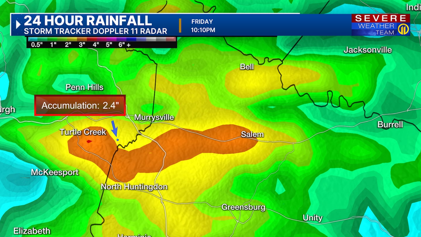
Storms developed around 3 p.m. over Allegheny and Westmoreland counties with repeated rounds of heavy rain “training” over the same areas.
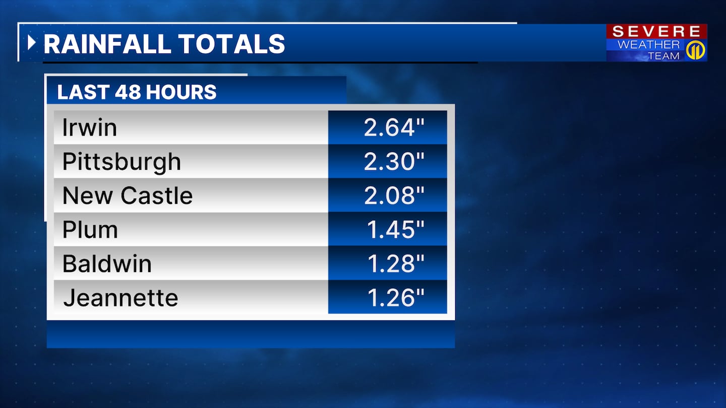
More than 2.5 inches of rain fell in Irwin, Westmoreland County and more than 2.25 inches of rain fell in Pittsburgh.
The hills and valleys in our area made matters worse, quickly funneling the runoff into streets and neighborhoods. Several cars were stranded on flooded roadways and Swift water rescue crews were called into action.
More showers and storms are expected Sunday and could bring more heavy downpours.
READ THE LATEST ON STORM DAMAGE AND CLEAN-UP EFFORTS BELOW
UPDATE 2:20 p.m.
Nearly everyone who lost power has service back. As of 2:20 p.m., fewer than 200 outages remained.
UPDATE 7:00 p.m. Saturday
County Executive Sara Innamorato has declared a state of emergency for Allegheny County.
The decision comes as more rain is expected to roll in on Sunday. A Flood Watch has been issued for Allegheny County. It will go in effect Sunday morning.
UPDATE 12:10 p.m. Saturday
There are now just over 1,100 people without power throughout Western Pennsylvania.
UPDATE 10:20 a.m. Saturday
Allegheny County officials are starting to assess damage from Friday’s flooding.
The county says the heavy rain and subsequent floods primarily impacted Monroeville, Penn Hills, Pitcairn, White Oak, McKeesport, North Versailles and parts of Plum.
At least four rescues were made from flooded homes or vehicles, but there are no reports of serious injuries are deaths from the storms.
>>> At least 10 people displaced after flash flooding hit North Versailles
Now, county officials say the emergency services department is working to confirm the locations and the extent of damage from multiple reported landslides.
Additionally, emergency services and public works are focusing on cleaning up and assessing damage from flooding.
With additional rain expected on Sunday and Monday, county officials urge people to make sure storm grates and downspouts are clear, and creeks are flowing without obstruction to avoid additional flooding.
UPDATE 9:30 a.m. Saturday
In Monroeville, some roadways are still closed after damaging floods.
Officials say Rosecrest Drive between Oak Street and School Street/Wall Avenue is still closed. We captured major flooding on Wall Avenue on Friday that left the roadway buckled.
Hillside Avenue between Shalimar Court and Mosside Boulevard will also be closed “for an extended period of time.”
UPDATE 8:30 a.m. Saturday
Channel 11 was on scene as a man was pulled through a flooded creek to safety in New Castle on Friday night. We’re told he was taken to a hospital to be evaluated, but he’s ok.
UPDATE 7:50 a.m. Saturday
There are still around 2,000 people without power in our region, according to Duquesne Light Company and West Penn Power outage maps.
In Murrysville, all but Trafford Road have reopened.
UPDATE 10:55 p.m.
Duquesne Light Company and West Penn Power reported nearly 2,000 power outages after storms on Friday.
Click here for more details on power outages.
UPDATE 10:10 p.m.
Vehicles were almost completely submerged in water in Murrysville. The Murrysville Police Department asked drivers to avoid the following roads.
- Old William Penn Highway (from Cozy Inn to Export Tire)
- Hills Church Road
- Van Buren
- School Road South
- Crowfoot Road
- Haymaker Farm Road
- Laurel Oak Circle
- Kemerer Hollow Road
- Puckety Drive
- Pleasant Valley Road
- Trafford Road
- Meadowbrook
UPDATE 9:40 p.m.
The Avonworth School District graduation ceremony was also postponed because of poor weather conditions on Friday. The ceremony is now scheduled to take place on Saturday at 11 a.m.
Graduates should be at the school by 10:30 a.m. at the Stadium Field House.
The event will also be livestreamed.
Click here to watch the live stream.
UPDATE 9:05 p.m.
A Flash Flood Warning has been issued for parts of Allegheny and Beaver counties. The National Weather Service said the warning is expected to be in place until 11 p.m.
A FLASH FLOOD WARNING has been issued for the shaded portion of Allegheny county. Take action now.
— Scott Harbaugh (@WPXIScott) June 7, 2025
Interactive radar: https://t.co/FZ9C6meUjq
Download the FREE Severe Weather Team 11 App for alerts: https://t.co/SNtbZ2FQ77 #WPXI #WPXIStorm #SevereWeather #PAWX pic.twitter.com/vwMEsOny08
UPDATE 7:55 p.m.
As a result of significant flooding, the Monroeville Foundation said Monroeville Community Day will be postponed. It was originally scheduled to take place on Saturday.
Organizers said they will move forward with the event after they make the area safe again.
“Today’s downpour left the fields and grounds saturated and unsuitable for hosting the event,” said Municipal Manager Alex Graziani. “The vendor area, car show field, and parking zones are not in a condition to safely accommodate attendees.”
UPDATE 6:40 p.m.
PennDOT has released a list of road closures and restrictions caused by today’s heavy rain and severe weather in place in Allegheny County. The following roads are closed or restricted:
- Route 48 (Mosside Boulevard) between Haymaker Road and Route 130 in the Municipality of Monroeville due to flooding and downed utilities
- Route 48 (Mosside Boulevard) between Route 130 and Wall Avenue in the Municipality of Monroeville and North Versailles Township due to downed utilities
- Route 48 (Jacks Run Road) between Lincoln Way and McKee Road in White Oak Borough due to a landslide
- Route 51 (Saw Mill Run Boulevard) between Crane Avenue and I-376 (Parkway West) in the City of Pittsburgh, due to flooding
- Route 2112 (Electric Avenue) between Route 30 and the Tri-boro Expressway in North Braddock and East Pittsburgh boroughs due to a landslide
UPDATE 6:20 p.m.: PennDOT said Route 51 is closed in both directions between Crane Avenue and I-375 in the City of Pittsburgh because of flooding.
UPDATE 6:05 p.m.: PennDOT said Route 48 (Mosside Blvd) is closed between Haymaker and Route 130 in Monroeville because of flooding and downed wires.

UPDATE 5:45 p.m.: A vehicle became submerged along a flooded road in the Monroeville area.

UPDATE 5:30 p.m.: The National Weather Service has issued a new Flash Flood Warning for parts of Allegheny and Westmoreland counties.
A FLASH FLOOD WARNING has been issued for the shaded portion of Allegheny county. Take action now.
— Scott Harbaugh (@WPXIScott) June 6, 2025
Interactive radar: https://t.co/FZ9C6meUjq
Download the FREE Severe Weather Team 11 App for alerts: https://t.co/SNtbZ2FQ77 #WPXI #WPXIStorm #SevereWeather #PAWX pic.twitter.com/pDabu2zmhJ
UPDATE 5:20 p.m.: A Flash Flood Warning for parts of Allegheny County and Westmoreland County has been extended.
Flash Flood Warning continues for Monroeville PA, Plum PA and Murrysville PA until 8:00 PM EDT pic.twitter.com/a9dKTb5Ftc
— NWS Pittsburgh (@NWSPittsburgh) June 6, 2025
A second warning issued for parts of east central Allegheny County has also been extended until 8 p.m.
Flash Flood Warning continues for West Mifflin PA, McKeesport PA and Munhall PA until 8:00 PM EDT pic.twitter.com/SCROqQxZ9B
— NWS Pittsburgh (@NWSPittsburgh) June 6, 2025
UPDATE: 4:55 p.m.: The Flash Flood Warning issued for parts of Allegheny County has been extended until 7:45 p.m., the National Weather Service said.
A FLASH FLOOD WARNING has been issued for the shaded portion of Allegheny county. Take action now.
— Scott Harbaugh (@WPXIScott) June 6, 2025
Interactive radar: https://t.co/FZ9C6meUjq
Download the FREE Severe Weather Team 11 App for alerts: https://t.co/SNtbZ2FQ77 #WPXI #WPXIStorm #SevereWeather #PAWX pic.twitter.com/hnROW5MVxH
UPDATE 4:45 p.m.: As a result of the inclement weather, the North Allegheny School District will postpone its graduation ceremony.
The ceremony, originally scheduled for tonight, will now be held tomorrow morning at 9:30 a.m.
The district will send an email and SchoolMessenger notice to senior families with more information.
“We understand that this change may impact plans made by our students and families. However, the health, safety, and well-being of our students, staff, and guests will always remain our highest priority. We look forward to a memorable celebration of our graduates and sincerely thank you for your understanding and flexibility as we ensure everyone’s safety for this special event,” the district said.
North Allegheny said an original message indicated the ceremony would start at 10 a.m. but that is not true.
UPDATE 4:30 p.m.: Several Channel 11 viewers have shared photos showing flooding at the Woodland Hills football field.

UPDATE: 4:10 P.M.: A Flash Flood Warning has been issued for parts of Allegheny and Westmoreland counties.
The National Weather Service said the warning includes east central Allegheny County and west central Westmoreland County. It is expected to be in effect until at least 6:00 p.m.
Flash Flood Warning including West Mifflin PA, McKeesport PA and Munhall PA until 6:00 PM EDT pic.twitter.com/mp4QgLBLPf
— NWS Pittsburgh (@NWSPittsburgh) June 6, 2025
UPDATE 3:10 p.m.: A Flash Flood Warning has been issued for parts of Allegheny and Westmoreland counties until 6 p.m.
A FLASH FLOOD WARNING has been issued for the shaded portion of Allegheny county. Take action now.
— Scott Harbaugh (@WPXIScott) June 6, 2025
Interactive radar: https://t.co/FZ9C6meUjq
Download the FREE Severe Weather Team 11 App for alerts: https://t.co/SNtbZ2FQ77 #WPXI #WPXIStorm #SevereWeather #PAWX pic.twitter.com/GBjeeFwyV7
UPDATE 2:45 p.m.: A Flash Flood Warning has been issued for parts of Fayette and Greene counties until 4:45 p.m. NWS said some locations that will experience flash flooding include Morgantown, Point Marion, Brandonville, Bruceton Mills, Laurel Run, Clifton Mills, Cheat Lake and Hazelton.
UPDATE 2:20 p.m.: A Severe Thunderstorm Warning has been issued for parts of Allegheny, Armstrong, Fayette and Westmoreland counties until 2:45 p.m.
A Flash Flood Warning is also in effect for part of Westmoreland County until 4:15 p.m. The NWS said some locations that will experience flash flooding include Murrysville, Avonmore and Saltsburg.
SEVERE THUNDERSTORM WARNING has been issued for the shaded portion of Allegheny county. Take precautions now.
— Scott Harbaugh (@WPXIScott) June 6, 2025
Interactive radar: https://t.co/FZ9C6meUjq
Download the FREE Severe Weather Team 11 App for alerts: https://t.co/SNtbZ2FQ77 #WPXI #WPXIStorm #SevereWeather #PAWX pic.twitter.com/vSewSXVgnw
-------
Scattered showers and slow-moving thunderstorms will disrupt your plans through the evening, so check the Severe Weather Team 11 forecast before heading out.
>>TRACK THE RAIN AND STORMS HERE<<<
Heavy downpours will create localized flooding and quick-changing driving conditions, so watch for ponding of water on roadways, especially in poor drainage areas. Damaging wind gusts may also develop with stronger storms, and most of the wet weather will gradually end through the evening.
We’ll get a break between systems Saturday with mainly dry weather and more sunshine throughout the day, but more showers and storms return Sunday.
Right now, Severe Weather Team 11 is tracking the threat for a morning round of showers and storms with scattered storms possible through the afternoon. Any storms that develop could bring the threat for damaging winds.
Have the Severe Weather Team 11 app for the latest alerts, watches and warnings.
Download the FREE WPXI News app for breaking news alerts.
Follow Channel 11 News on Facebook and Twitter. | Watch WPXI NOW
©2025 Cox Media Group
/cloudfront-us-east-1.images.arcpublishing.com/cmg/XCUXZC2XYZHCRGNNGKFEX6U3LQ.png)


