PITTSBURGH — Severe thunderstorms blew through the Western Pennsylvania area on Thursday evening. Here’s the latest.
CLICK HERE TO TRACK THE STORMS WITH LIVE RADAR.
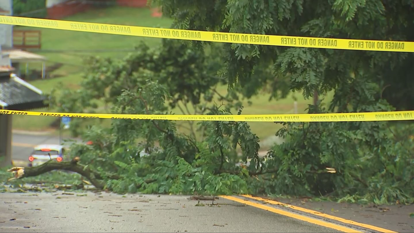
CLICK HERE FOR PHOTOS OF THE DAMAGE LEFT BEHIND.
CLICK HERE TO TRACK THE NUMBER OF POWER OUTAGES REPORTED IN OUR AREA.
UPDATE 6:40 p.m.
All counties have been cleared from the Severe Thunderstorm Watch issued for the evening.
UPDATE 6:15 p.m.
The Pittsburgh International Airport said its systems are back online after a lightning strike caused a power outage.

UPDATE 5:40 p.m.
Firefighters tell Channel 11 that a house fire that broke out in Pittsburgh’s Manchester neighborhood may have been caused by a lightning strike during severe storms on Thursday.
Click here to read more about that fire.
UPDATE 4:55 p.m.
A local animal shelter is closed because of a power outage.
Animal Friends, located in North Hills, said all appointments with the clinic and university classes are canceled Thursday night.
Anyone with a pickup at the clinic can proceed as usual.
UPDATE: 4:50 p.m.
A Severe Thunderstorm Warning has been issued for parts of Fayette, Indiana and Westmoreland counties. The warning is expected to last until at least 5:30 p.m.
Severe Thunderstorm Warning including Indiana PA, Punxsutawney PA and Reynoldsville PA until 5:30 PM EDT. This storm will contain wind gusts to 70 MPH! pic.twitter.com/IzzCTpY5vs
— NWS Pittsburgh (@NWSPittsburgh) June 11, 2026
UPDATE 4:45 p.m.
A tree is blocking Steuben Street in Crafton Heights. Police at the scene said wires were also pulled down.
UPDATE 4:35 p.m.
A tree fell across E Sycamore Street in Mount Washington. Pittsburgh Public Works employees are currently working to remove it.

UPDATE 4:05 p.m.
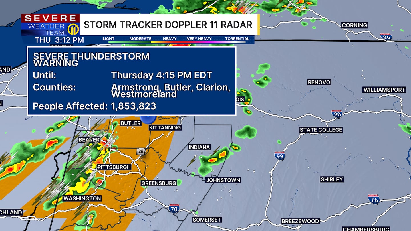
A new severe thunderstorm warning has been issued for parts of Allegheny, Armstrong, Butler, Indiana and Westmoreland counties.
That warning is expected to last until at least 4:45 p.m.
UPDATE 3:55 p.m.
A new severe thunderstorm warning has been issued for parts of Allegheny, Butler, Fayette, Washington and Westmoreland counties. The warning is expected to last until at least 4:15 p.m.
UPDATE 3:30 p.m.
The Hookstown Volunteer Fire Department said Route 30 is closed between Tower Lane and Pittsburgh Grade Road because of a tree that pulled down wires.
UPDATE 3:15 p.m.: A Severe Thunderstorm Warning has been issued for the following areas until 4:15 p.m.:
- Allegheny County in southwestern Pennsylvania
- Washington County in southwestern Pennsylvania
- Northwestern Westmoreland County in southwestern Pennsylvania
- Southwestern Armstrong County in west central Pennsylvania
- Butler County in west central Pennsylvania
- Eastern Beaver County in western Pennsylvania
- Southeastern Lawrence County in western Pennsylvania
UPDATE 3:04 p.m.: A Severe Thunderstorm Warning has been issued for the following areas until 4 p.m.:
- Northwestern Fayette County in southwestern Pennsylvania
- Greene County in southwestern Pennsylvania
- Southern Washington County in southwestern Pennsylvania
UPDATE 2:36 p.m.: A Severe Thunderstorm Warning has been issued for the following areas until 3:13 p.m.:
- Northwestern Allegheny County in southwestern Pennsylvania
- Northwestern Washington County in southwestern Pennsylvania
- Southwestern Butler County in west central Pennsylvania
- Beaver County in western Pennsylvania
- Southern Lawrence County in western Pennsylvania
CLICK HERE TO TRACK THE RAIN AND STORMS
_____________________________
More humidity today as high temperatures push back into the mid to upper 80s. The bulk of the morning should be quiet, but we’ll watch as another round of scattered storms develops this afternoon. Not everyone will see a storm today, but anything that pops in this environment could contain very heavy rain and some gusty winds.
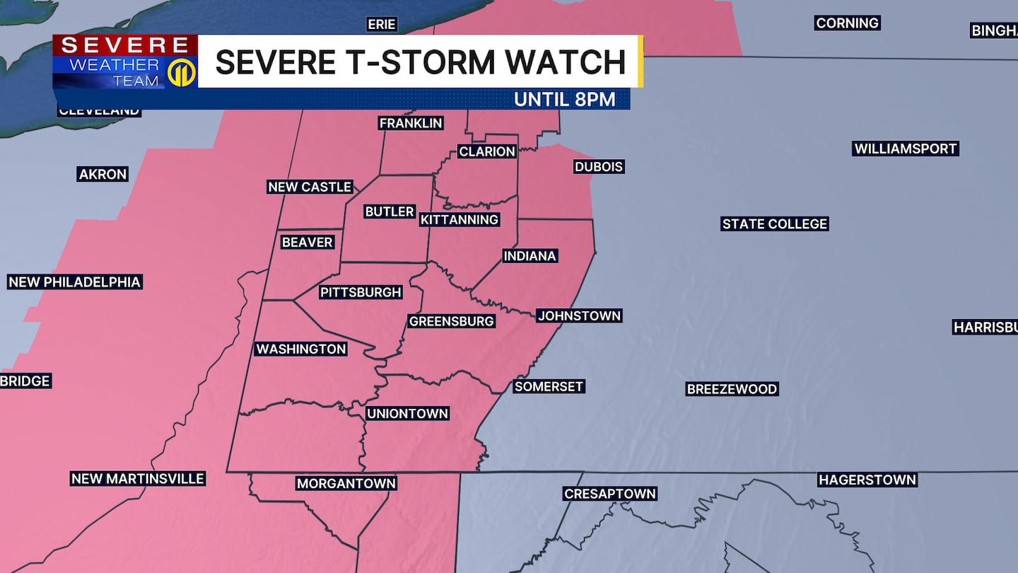
A Severe Thunderstorm Watch is in effect for the entire Pittsburgh area until 8 p.m. Make sure to stay weather aware and have a way to get alerts. Severe storms could bring damaging winds, hail, heavy rainfall, frequent lightning and downburst winds.
The cold front itself crosses Friday afternoon, bringing another round of showers and a few storms. Depending on the exact timing, areas south and east of Pittsburgh may be most likely to see a storm with drier and more stable air pushing in for areas north and west sooner. Regardless, much less humidity will be felt by Friday evening with overnight lows dipping into the low 60s.
Saturday will be warm but comfortable before another uptick in humidity levels on Sunday. A secondary cold front will bring a higher chance for storms late in the day before a cooler and much drier air mass settles in for next week. Most days will be in the 70s!
Download the FREE WPXI News app for breaking news alerts.
Follow Channel 11 News on Facebook and Twitter. | Watch WPXI NOW
©2026 Cox Media Group
/cloudfront-us-east-1.images.arcpublishing.com/cmg/XCUXZC2XYZHCRGNNGKFEX6U3LQ.png)